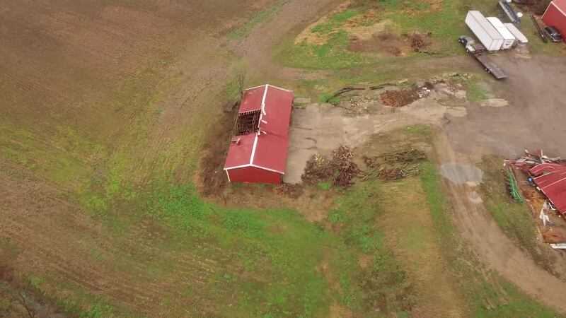
Two tornadoes touched down during severe storms Wednesday evening in Clark County: one in Enon and the other six miles west of Springfield, the National Weather Service confirmed this evening.
UPDATE @ 6:55 p.m.
Two EFO tornadoes spawned during storms Wednesday in Clark County, with neither resulted in injuries.
The second was six miles west of Springfield, which formed at 6:58 p.m. Wind speeds are estimated at 75 to 80 mph. The twister’s path was 40 yards wide and it traveled for 180 yards.
Widespread damage was spotted in the Tecumseh Trails subdivision and along North Tecumseh Road. Most of the damage was due to straight line winds, according to the NWS.
The first tornado formed began at 6:51 p.m. Wednesday evening and lasted approximately one minute. Winds speeds are estimated at 75 to 80 mph.
The width of tornado’s path was 40 yards; the length of the path was 150 yards.
<b>MORE ON STORMS</b><br/><b><i>» <a href="http://www.mydaytondailynews.com/news/photos-must-see-images-showing-the-destruction-the-1974-xenia-tornado/h52jbCvygBE9LO2A551NaN/" target="_blank">Photos: 25 must-see images showing the destruction of the 1974 Xenia tornado</a></i></b><br/><i><b>» <a href="http://www.mydaytondailynews.com/news/local/most-recent-tornadoes-the-dayton-region/lRfBV9w6Pa7WKstaFsbX4J/" target="_blank">10 most recent tornadoes in the Dayton region</a></b></i><br/><i><b>» </b></i><a href="http://www.mydaytondailynews.com/weather/photos-these-lightning-images-will-make-you-appreciate-the-beauty-thunderstorms/DOVqvq2Y5ub1KIg8WVzi2I/" target="_blank"><b><i>Photos: These 13 lightning images will make you appreciate the beauty of thunderstorms</i></b></a><br/>
Here is the statement released by the NWS:
The first evidence of damage occurred to a home and farm along Dayton-Springfield Road, southwest of Enon.
While there were numerous homes in the area which sustained tree damage and lightweight debris damage, the vast majority of this damage was from straightline winds estimated at 70 mph. The wind damage was southwest to northeast with no evidence of tornadic winds making direct contact with the ground nor debris found on downwind sides of buildings.
There was embedded damage to a farm home and barns where large sections of roofing material was peeled off and lofted, causing damage to the downwind home. There was additional roof damage to the home and 2 additional farm buildings. The southward facing garage door to the home was blown inward. Two combines located in one of the outbuildings were pushed downwind, with the outbuilding
itself collapsed.
Where there was evidence of tornado damage was in the
downwind/northeast facing wall of the home and one of the barns, where debris splatter was observed. Because of heavy rain after the passage of the storm, direct ground damage indicative of a tornado in contact with the ground was inconclusive.
See the complete report and map at the National Weather Service website.
UPDATE @ 1:23 p.m.
The National Weather Service confirms a tornado caused damage near Enon in Clark County during last night’s storms.
The damage was surveyed today by NWS meteorologists in the area west and north of Enon.
The team identified two areas of EF0 tornadic damage. More details will be released later Thursday.
The EF-Scale Rating used by the NWS:
EF0...wind speeds 65 to 85 mph.
EF1...wind speeds 86 to 110 mph.
EF2...wind speeds 111 to 135 mph.
EF3...wind speeds 136 to 165 mph.
EF4...wind speeds 166 to 200 mph.
EF5...wind speeds greater than 200 mph
FIRST REPORT
The National Weather Service has announced they will be conducting storm survey to assess damage following Wednesday nights severe thunderstorms.
The survey will take place in Clark and Greene counties.
A final assessment including results from the survey are expected to be completed and released by this evening, the weather service said.


